Fort Henry is the name of:
Fort Schuyler is a preserved 19th century fortification in the New York City borough of the Bronx. It houses a museum, the Stephen B. Luce Library, and the Marine Transportation Department and Administrative offices of the State University of New York Maritime College. It is considered one of the finest examples of early 19th century fortifications. The fort was named in honor of Major General Philip Schuyler of the Continental Army.

Fort William and Mary was a colonial fortification in Britain's worldwide system of defenses, defended by soldiers of the Province of New Hampshire who reported directly to the royal governor. The fort, originally known as "The Castle," was situated on the island of New Castle, New Hampshire, at the mouth of the Piscataqua River estuary. It was renamed Fort William and Mary circa 1692, after the accession of the monarchs William III and Mary II to the British throne. It was captured by Patriot forces, recaptured, and later abandoned by the British in the Revolutionary War. The fort was renamed Fort Constitution in 1808 following rebuilding. The fort was further rebuilt and expanded through 1899 and served actively through World War II.

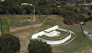
Fort Pickens is a pentagonal historic United States military fort on Santa Rosa Island in the Pensacola, Florida, area. It is named after American Revolutionary War hero Andrew Pickens. The fort was completed in 1834 and was one of the few forts in the South that remained in Union hands throughout the American Civil War. It remained in use until 1947. Fort Pickens is included within the Gulf Islands National Seashore, and as such, is administered by the National Park Service.

Fort Monroe is a former military installation in Hampton, Virginia, at Old Point Comfort, the southern tip of the Virginia Peninsula, United States. It is currently managed by partnership between the Fort Monroe Authority for the Commonwealth of Virginia, the National Park Service, and the city of Hampton as the Fort Monroe National Monument. Along with Fort Wool, Fort Monroe originally guarded the navigation channel between the Chesapeake Bay and Hampton Roads—the natural roadstead at the confluence of the Elizabeth, the Nansemond and the James rivers.

Craney Island is a point of land in the independent city of Portsmouth in the South Hampton Roads region of eastern Virginia in the United States. The location, formerly in Norfolk County, is near the mouth of the Elizabeth River opposite Lambert's Point on Hampton Roads. It is home to the Craney Island US Naval Supply Center, managed by the U.S. Army Corps of Engineers.
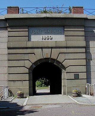
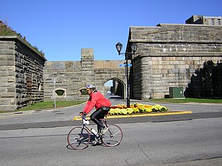
Fort Warren is a historic fort on the 28-acre (110,000 m2) Georges Island at the entrance to Boston Harbor. The fort is named for Revolutionary War hero Dr. Joseph Warren, who sent Paul Revere on his famous ride, and was later killed at the Battle of Bunker Hill. The name was transferred in 1833 from the first Fort Warren – built in 1808 – which was renamed Fort Winthrop.

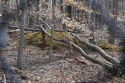
A redoubt is a fort or fort system usually consisting of an enclosed defensive emplacement outside a larger fort, usually relying on earthworks, although some are constructed of stone or brick. It is meant to protect soldiers outside the main defensive line and can be a permanent structure or a hastily constructed temporary fortification. The word means "a place of retreat". Redoubts were a component of the military strategies of most European empires during the colonial era, especially in the outer works of Vauban-style fortresses made popular during the 17th century, although the concept of redoubts has existed since medieval times. A redoubt differs from a redan in that the redan is open in the rear, whereas the redoubt was considered an enclosed work.
Fort Barrancas (1839) or Fort San Carlos de Barrancas is a United States military fort and National Historic Landmark in the former Warrington area of Pensacola, Florida, located physically within Naval Air Station Pensacola, which was developed later around it.

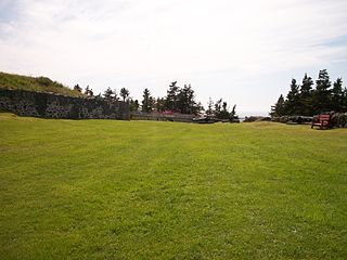
York Redoubt is a redoubt situated on a bluff overlooking the entrance to Halifax Harbour at Ferguson's Cove, Nova Scotia, Canada, originally constructed in 1793. It was designated a National Historic Site of Canada in 1962.
Fort Hunt Park is a public park located in Fort Hunt, Fairfax County, Virginia. It is administered by the National Park Service as part of the George Washington Memorial Parkway. The park preserves the remains of the eponymous Fort Hunt, portions of which date to the time of the Spanish–American War. The park was named after Brigadier General Henry Hunt, who served as chief of artillery of the Army of the Potomac during the Civil War. Remains of several of the fort's original batteries, including Battery Mount Vernon, Battery Robinson, and Battery Sater, and Battery Porter, have been preserved, and may still be visited today. The structures have been stabilized enough that visitors are able to climb on them without difficulty. Besides the batteries, the battery commander's station still stands; in addition, a flagpole has been erected as a memorial to the intelligence officers who served at the fort during World War II.
The city of Winchester, Virginia, and the surrounding area, were the site of numerous battles during the American Civil War, as contending armies strove to control the lower Shenandoah Valley. Winchester changed hands more often than any other Confederate city.

Fort Southerland, also known as Redoubt E and possibly Fort Diamond, is a redoubt built during the American Civil War to protect Camden, Arkansas. Confederate forces built it along with four other redoubts in early 1864 after a Union victory in the Little Rock campaign the previous year. Fort Southerland is about the size of a city block and is roughly oval. It could hold three cannons. When Union forces captured Camden in April 1864 during the Camden Expedition, they improved the defenses of the five redoubts, which were not sufficient for proper defense of the city. After the Confederates retook Camden later that month, they continued to improve the city's defenses.

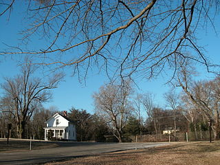
Built by Confederate Lieutenant Collier and Virginia militia with the aid of Federal prisoners, the Fort Collier redoubt guarded the north entrance of Winchester, Virginia on the east side of the Martinsburg Pike. During later Federal occupations, it was known as Battery No. 10. The fort was set on low ground, and generally offered little military advantage, except as a guard post for the pike. Lieutenant General Jubal Early used it as part of his defensive works in the Third Battle of Winchester.
Castle Hill is an area containing the remains of both French and British fortifications, overlooking the town of Placentia in Newfoundland and Labrador, Canada. The site was originally established in order to protect the French fishing interests in Terre-Neuve (Newfoundland) and the approaches to the French colony of Canada.

Fort Revere is an 8-acre (3.2 ha) historic site situated on a small peninsula located in Hull, Massachusetts. It is situated on Telegraph Hill in Hull Village and contains the remains of two seacoast fortifications, one from the American Revolution and one that served 1898–1947. There are also a water tower with an observation deck, a military history museum and picnic facilities. It is operated as Fort Revere Park by the Metropolitan Park System of Greater Boston.

The Redoubt St. Archangel Michael Site, also known as the Old Sitka Site and now in Old Sitka State Historical Park, is a National Historic Landmark near Sitka, Alaska. Now of archaeological interest, the site, about 7 miles (11 km) north of Sitka at the end of Halibut Point Road, was the site of the early Russian-American Company settlement known as Redoubt St. Archangel Michael. It was the first non-Native settlement on Baranof Island. It was declared a National Historic Landmark in 1962, and was made a state park in 1966.

Redoubt No. 2, also known as Fort No Name, is a historic archaeological site located near Stafford, Stafford County, Virginia. The site was the central of the three, perhaps four, Federal defensive fortifications ordered constructed in early (February) 1863 during the American Civil War to protect the approaches to the Union supply depot at Aquia Creek Landing, Stafford, Virginia. Redoubt No.2 is an earthen field fortification that is nearly 95 feet square.
Fort Marrow is a historic American Civil War fort and archaeological site located near Huttonsville, Randolph County, West Virginia. It was built by the Union Army as part of the defenses for Camp Elkwater. It is a seven-sided, enclosed earthen redoubt. Associated with it is a nearby tent / hut site, now represented by 10 depressions in the earth.
The Civil War Trust's Civil War Discovery Trail is a heritage tourism program that links more than 600 U.S. Civil War sites in more than 30 states. The program is one of the White House Millennium Council's sixteen flagship National Millennium Trails. Sites on the trail include battlefields, museums, historic sites, forts and cemeteries.